


| STORM REPORTS Issued by the Storm Prediction Center |
| Select date for other reports |
April 16, 2026 |
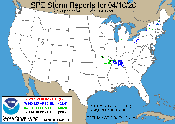 |
| 130 reports sorted by the latest reports first |
| Apr 16 9:53 pm CDT |
| VERMONT - Orange COUNTY - 3 MILES EAST-NORTHEAST OF Ainsworth State P |
| WIND - Tree down on power lines near intersection of Chelsea Rd and Baptist St. (Burlington, VE) |
| Apr 16 9:19 pm CDT |
| TENNESSEE - Coffee COUNTY - Tullahoma |
| WIND - Reports of trees down on Ashley drive in Tullahoma. Relayed via #tSpotter. (Nashville, TE) |
| Apr 16 9:05 pm CDT |
| NEW HAMPSHIRE - Grafton COUNTY - 5 MILES WEST OF Lincoln |
| WIND - Delayed report. Trees and several large branches partially blocking sections of Lost River Road... stretching from NH HWY 116 east to the Wildwood Campground. (Portland, ME) |
| Apr 16 8:58 pm CDT |
| NEW HAMPSHIRE - Grafton COUNTY - Lisbon |
| WIND - Delayed report. Trees downed on power lines in Lisbon. Power outages also reported. (Portland, ME) |
| Apr 16 8:53 pm CDT |
| NEW HAMPSHIRE - Grafton COUNTY - 1 MILE SOUTHWEST OF Bath |
| WIND - Delayed report. Multiple trees down on Sawyer Hill Road between Goose Lane and NH HWY 112. Largest tree diameter between 12 and 18 inches. (Portland, ME) |
| Apr 16 8:50 pm CDT |
| NEW HAMPSHIRE - Grafton COUNTY - 4 MILES EAST OF Newbury |
| HAIL - 1.25 in - Delayed report. Social media photos of hail up to 1.25 inches in diameter in Center Haverhill near intersection of Route 116 and French Pond Rd. Wind damage reports str (Portland, ME) |
| Apr 16 8:48 pm CDT |
| NEW HAMPSHIRE - Grafton COUNTY - 4 MILES SOUTH OF Woodsville |
| HAIL - 1.50 in - Hail up to 1.5 inches in North Haverhill on Route 10. Spotter ID: HL590. (Portland, ME) |
| Apr 16 8:40 pm CDT |
| VERMONT - Orange COUNTY - 3 MILES EAST-NORTHEAST OF Ainsworth State P |
| WIND - Corrects previous tstm wnd dmg report time from 3 ENE Ainsworth State Park. Tree down on power lines near intersection of Chelsea Rd and Baptist St. (Burlington, VE) |
| Apr 16 8:35 pm CDT |
| VERMONT - Washington COUNTY - Barre |
| WIND - Power pole down on Fairview St. (Burlington, VE) |
| Apr 16 8:33 pm CDT |
| TENNESSEE - Coffee COUNTY - Manchester |
| WIND - Wind damage to the roof of the library in Manchester... TN. Relayed via #tSpotter. (Nashville, TE) |
| Apr 16 8:30 pm CDT |
| VERMONT - Orange COUNTY - 2 MILES NORTHEAST OF East Orange |
| HAIL - 1.00 in - (Burlington, VE) |
| Apr 16 8:11 pm CDT |
| NEW YORK - Fulton COUNTY - Mayfield |
| HAIL - 1.00 in - Quarter size hail was reported in the village of Mayfield. (Albany, NY) |
| Apr 16 8:00 pm CDT |
| TENNESSEE - Marshall COUNTY - Chapel Hill |
| WIND - Tree down on a house in Chapel Hill. Time estimated. Relayed via #tSpotter. (Nashville, TE) |
| Apr 16 8:00 pm CDT |
| TENNESSEE - Wilson COUNTY - 2 MILES EAST OF Lebanon |
| WIND - About 3000 people without power in Wilson county according to EMA. (Nashville, TE) |
| Apr 16 7:54 pm CDT |
| TENNESSEE - Rutherford COUNTY - 6 MILES SOUTHWEST OF Murfreesboro |
| WIND - Report of large tree down on north side of Armstrong Valley Road in south Murfreesboro. (Nashville, TE) |
| Apr 16 7:50 pm CDT |
| TENNESSEE - Rutherford COUNTY - 8 MILES EAST-NORTHEAST OF Eagleville |
| WIND - Fence down in Rockvale due to the winds... relayed via broadcast media. (Nashville, TE) |
| Apr 16 7:49 pm CDT |
| TENNESSEE - Wilson COUNTY - 7 MILES NORTH OF Watertown |
| WIND - Tree down on the 7100 block of Trousdale Ferry Pike. (Nashville, TE) |
| Apr 16 7:49 pm CDT |
| TENNESSEE - Wilson COUNTY - 2 MILES NORTHEAST OF Lebanon |
| WIND - Reports of Utility poles down in between Hartmann Drive and Hunters Village drive. Time estimated. (Nashville, TE) |
| Apr 16 7:45 pm CDT |
| TENNESSEE - Dickson COUNTY - 3 MILES NORTH-NORTHWEST OF Dickson |
| WIND - Multiple reports of power outages in Dickson county. Relayed by amateur radio. (Nashville, TE) |
| Apr 16 7:37 pm CDT |
| TENNESSEE - Davidson COUNTY - 4 MILES EAST-NORTHEAST OF Antioch |
| WIND - Tree down in Antioch on Anderson Road. Time estimated from radar. (Nashville, TE) |
| Apr 16 7:36 pm CDT |
| TENNESSEE - Davidson COUNTY - 4 MILES NORTH OF Antioch |
| WIND - 62 mph - ASOS station peak gust KBNA Nashville Intl Airport. (Nashville, TE) |
| Apr 16 7:36 pm CDT |
| TENNESSEE - Davidson COUNTY - 4 MILES SOUTH OF Hermitage |
| WIND - Tree down and on a car. Time estimated from radar. Relayed via Facebook. (Nashville, TE) |
| Apr 16 7:31 pm CDT |
| TENNESSEE - Davidson COUNTY - 3 MILES SOUTHEAST OF Hermitage |
| WIND - No working red lights and down trees on central pike in Hermitage. Time estimated. (Nashville, TE) |
| Apr 16 7:30 pm CDT |
| KENTUCKY - Warren COUNTY - 2 MILES NORTHWEST OF Bowling Green |
| WIND - Tree down on power line on Gayle Way. (Louisville, KY) |
| Apr 16 7:29 pm CDT |
| TENNESSEE - Sumner COUNTY - Hendersonville |
| WIND - Power outages in Hendersonville. (Nashville, TE) |
| Apr 16 7:27 pm CDT |
| TENNESSEE - Robertson COUNTY - 1 MILE NORTH-NORTHWEST OF Springfield |
| WIND - Several trees down across Robertson county... including in Springfield... Orlinda... and Greenbrier. Power lines down as well. (Nashville, TE) |
| Apr 16 7:25 pm CDT |
| TENNESSEE - Williamson COUNTY - 5 MILES SOUTH OF Franklin |
| WIND - Multiple reports of trees down in Franklin. (Nashville, TE) |
| Apr 16 7:25 pm CDT |
| TENNESSEE - Sumner COUNTY - 1 MILE SOUTHEAST OF Hendersonville |
| WIND - Trees down on live power line... relayed via #tSpotter. (Nashville, TE) |
| Apr 16 7:25 pm CDT |
| KENTUCKY - Simpson COUNTY - 3 MILES SOUTH OF Woodburn |
| WIND - Large tree down over the 3000 block of Sportsman Lake Road. (Louisville, KY) |
| Apr 16 7:20 pm CDT |
| NEW HAMPSHIRE - Coos COUNTY - 2 MILES SOUTHEAST OF Dummer |
| WIND - Off-duty EMS (Post-storm). Observed downed trees along Rte 16 (Berlin Rd) near the Pontook Reservoir. (Portland, ME) |
| Apr 16 7:20 pm CDT |
| NEW HAMPSHIRE - Coos COUNTY - 3 MILES SOUTHEAST OF Dummer |
| HAIL - 1.50 in - Off-duty EMS Observed hail measured 1.5 inches in Dummer. Hail began at 8:20. (Portland, ME) |
| Apr 16 7:19 pm CDT |
| TENNESSEE - Davidson COUNTY - 1 MILE WEST OF Nashville |
| WIND - Huge tree down blocking shoulder and parts of the westbound lane on I-40. Relayed by Nash Severe WX. (Nashville, TE) |
| Apr 16 7:19 pm CDT |
| TENNESSEE - Sumner COUNTY - 1 MILE WEST-NORTHWEST OF Hendersonville |
| WIND - Trees blocking Sanders Ferry Road in Hendersonville. (Nashville, TE) |
| Apr 16 7:19 pm CDT |
| KENTUCKY - Simpson COUNTY - 3 MILES NORTHWEST OF Rapids |
| WIND - Tree down at the intersection of Rapids Road and Grace Road. Tree is blocking all lanes of traffic. (Louisville, KY) |
| Apr 16 7:13 pm CDT |
| KENTUCKY - Simpson COUNTY - 3 MILES EAST-SOUTHEAST OF Franklin |
| WIND - Very large tree down over the 900 block of Rapids Road. The tree is blocking all lanes of traffic. (Louisville, KY) |
| Apr 16 7:10 pm CDT |
| TENNESSEE - Davidson COUNTY - 5 MILES SOUTH-SOUTHWEST OF Ridgetop |
| WIND - Trees across both lanes of Crocker Springs Road. Time estimated via radar. (Nashville, TE) |
| Apr 16 7:06 pm CDT |
| TENNESSEE - Dickson COUNTY - Charlotte |
| WIND - Roof damage to a convenience store from strong winds. Time estimated from radar. (Nashville, TE) |
| Apr 16 7:05 pm CDT |
| MISSOURI - Dunklin COUNTY - 2 MILES NORTH OF Kennett |
| HAIL - 1.00 in - Corrects previous hail report from 2 N Kennett. Delayed report of quarter size hail 2 miles north of Kennett. (Memphis, TE) |
| Apr 16 7:05 pm CDT |
| NEW HAMPSHIRE - Coos COUNTY - Groveton |
| HAIL - 1.00 in - Quarter-sized hail in Groveton near intersection of Main Street and US Highway 3. (Portland, ME) |
| Apr 16 7:01 pm CDT |
| TENNESSEE - Hickman COUNTY - 1 MILE SOUTHWEST OF Centerville |
| WIND - Reports of power outages in Hickman county... with trees down in roads and roof damage. (Nashville, TE) |
| Apr 16 7:00 pm CDT |
| TENNESSEE - Williamson COUNTY - 1 MILE SOUTH-SOUTHWEST OF Fairview |
| WIND - Large limbs down on HWY 100. Traffic still moving. Time estimated. (Nashville, TE) |
| Apr 16 7:00 pm CDT |
| TENNESSEE - Dickson COUNTY - 1 MILE SOUTH OF Charlotte |
| WIND - Trees down on HWY 47 and 48 in Dickson county. Multiple reports of power outages. Relayed via Nash Severe WX. (Nashville, TE) |
| Apr 16 6:56 pm CDT |
| KENTUCKY - Logan COUNTY - 2 MILES NORTHEAST OF Russellville |
| WIND - Roof ripped off a barn. Time estimated from radar. (Louisville, KY) |
| Apr 16 6:52 pm CDT |
| TEXAS - Terrell COUNTY - Sanderson |
| HAIL - 2.00 in - Phone call with Fire Rescue confirmed 2 inch hail from a cell in Sanderson. (Midland/Odessa, TX) |
| Apr 16 6:47 pm CDT |
| KENTUCKY - Logan COUNTY - 2 MILES NORTH OF Russellville |
| WIND - Downed trees reported off Newtown Road. (Louisville, KY) |
| Apr 16 6:47 pm CDT |
| PENNSYLVANIA - Lawrence COUNTY - 3 MILES WEST-NORTHWEST OF Oakwood |
| WIND - Tree down; time estimated from radar. (Pittsburgh, PA) |
| Apr 16 6:45 pm CDT |
| TENNESSEE - Dickson COUNTY - Cumberland Furnace |
| WIND - Reports of tree damage relayed via social media. (Nashville, TE) |
| Apr 16 6:45 pm CDT |
| TENNESSEE - Robertson COUNTY - 2 MILES NORTHWEST OF Cedar Hill |
| WIND - Reports in Adams and Cedar Hill of numerous trees down... as well as several brush fires in the same area. (Nashville, TE) |
| Apr 16 6:45 pm CDT |
| KENTUCKY - Logan COUNTY - 3 MILES NORTHEAST OF Olmstead |
| WIND - Multiple trees and power lines down throughout southeast Logan County. (Louisville, KY) |
| Apr 16 6:34 pm CDT |
| TENNESSEE - Montgomery COUNTY - 4 MILES EAST OF Woodlawn |
| WIND - Trees down... with one on power line and on fire. Time estimated from radar. (Nashville, TE) |
| Apr 16 6:31 pm CDT |
| ARKANSAS - Clay COUNTY - 1 MILE SOUTHWEST OF Piggott |
| HAIL - 1.00 in - Report of quarter size hail in SW Piggott. (Memphis, TE) |
| Apr 16 6:30 pm CDT |
| KENTUCKY - Todd COUNTY - 3 MILES WEST-NORTHWEST OF Elkton |
| WIND - 59 mph - Kentucky Mesonet measured 59 mph gust. (Paducah, KY) |
| Apr 16 6:20 pm CDT |
| KENTUCKY - Christian COUNTY - 2 MILES SOUTH OF Hopkinsville |
| WIND - Tree uprooted on silvey rd in Hopkinsville Ky. (Paducah, KY) |
| Apr 16 6:16 pm CDT |
| TENNESSEE - Stewart COUNTY - 9 MILES SOUTHWEST OF Dover |
| WIND - Trees down on HWY 232 near Leatherwood Road reported by EMA. (Nashville, TE) |
| Apr 16 6:16 pm CDT |
| NEW YORK - Oswego COUNTY - 5 MILES SOUTHEAST OF Hannibal |
| WIND - Tree downed. (Buffalo, NY) |
| Apr 16 6:12 pm CDT |
| TENNESSEE - Benton COUNTY - 6 MILES SOUTH OF Big Sandy |
| WIND - Several trees and power lines down across Benton County. (Memphis, TE) |
| Apr 16 6:11 pm CDT |
| TENNESSEE - Henry COUNTY - 4 MILES NORTH OF Vale |
| WIND - Report of a tree down on Mansfield Road at Vale Road. (Memphis, TE) |
| Apr 16 6:08 pm CDT |
| KENTUCKY - Christian COUNTY - 1 MILE NORTH-NORTHEAST OF Hopkinsville |
| WIND - Shingles blown off roof in Hopkinsville. Winds on the bypass observed at 50-55 mph. Power poles knocked down in Hopkinsville. (Paducah, KY) |
| Apr 16 6:05 pm CDT |
| KENTUCKY - Christian COUNTY - 1 MILE NORTH-NORTHEAST OF Hopkinsville |
| WIND - Roof blown off a garage. (Paducah, KY) |
| Apr 16 6:02 pm CDT |
| TENNESSEE - Stewart COUNTY - 11 MILES WEST-SOUTHWEST OF Dover |
| WIND - Trees and power lines down on Donelson Parkway at the TN River Bridge. Reported by EMA. (Nashville, TE) |
| Apr 16 6:01 pm CDT |
| TENNESSEE - Henry COUNTY - 5 MILES SOUTH-SOUTHWEST OF Paris Landing |
| WIND - Tree down over the intersection of west and East Antioch Road. (Memphis, TE) |
| Apr 16 5:58 pm CDT |
| TENNESSEE - Henry COUNTY - 4 MILES SOUTH OF Buchanan |
| WIND - Tree down across Log Cabin Road and Buchanan Road at Cay Lawrence Road. (Memphis, TE) |
| Apr 16 5:54 pm CDT |
| NEW YORK - Oneida COUNTY - Forestport |
| HAIL - 1.00 in - Hail size estimated from video posted to broadcast media social media page. (Binghamton, NY) |
| Apr 16 5:44 pm CDT |
| MISSOURI - Miller COUNTY - 3 MILES EAST-SOUTHEAST OF Etterville |
| HAIL - 2.50 in - Pictures of tennis ball size hail near Eugene. (Springfield, MO) |
| Apr 16 5:43 pm CDT |
| TENNESSEE - Henry COUNTY - 3 MILES SOUTHEAST OF Como |
| WIND - Tree down on Henry Midway road. (Memphis, TE) |
| Apr 16 5:34 pm CDT |
| NEW YORK - St. Lawrence COUNTY - Cranberry Lake |
| WIND - Trees down along Mill Road near Silver Lake. (Burlington, VE) |
| Apr 16 5:32 pm CDT |
| MISSOURI - Cole COUNTY - 2 MILES NORTH OF Eugene |
| HAIL - 1.25 in - Corrects previous hail report from 2 N Eugene. (St. Louis, MO) |
| Apr 16 5:26 pm CDT |
| TENNESSEE - Weakley COUNTY - 3 MILES EAST-SOUTHEAST OF Martin |
| WIND - Report of a tree on a home on Ralston Road in Martin. (Memphis, TE) |
| Apr 16 5:26 pm CDT |
| MISSOURI - Cole COUNTY - 2 MILES NORTH OF Eugene |
| HAIL - 1.00 in - (St. Louis, MO) |
| Apr 16 5:25 pm CDT |
| MISSOURI - Cole COUNTY - Eugene |
| HAIL - 2.50 in - Delayed report... time estimated from radar. Emergency management estimated hail between golf ball and tennis ball size... though photo was representative of tennis bal (St. Louis, MO) |
| Apr 16 5:20 pm CDT |
| MISSOURI - Miller COUNTY - Etterville |
| HAIL - 1.75 in - Multiple reports of Golf Ball size hail reported by the public... relayed by Regional Skywarn HAM Operator. (Springfield, MO) |
| Apr 16 5:18 pm CDT |
| MISSOURI - Miller COUNTY - 2 MILES EAST OF Etterville |
| HAIL - 1.00 in - Report from mPING of Quarter size hail. (Springfield, MO) |
| Apr 16 5:17 pm CDT |
| KENTUCKY - Marshall COUNTY - Faridealing |
| WIND - Trees down... spotter estimated 60 mph wind. (Paducah, KY) |
| Apr 16 5:13 pm CDT |
| KENTUCKY - Marshall COUNTY - 1 MILE EAST-NORTHEAST OF Benton |
| HAIL - 1.00 in - (Paducah, KY) |
| Apr 16 5:10 pm CDT |
| KENTUCKY - Marshall COUNTY - 6 MILES SOUTH OF Calvert City |
| HAIL - 1.00 in - (Paducah, KY) |
| Apr 16 5:08 pm CDT |
| TENNESSEE - Obion COUNTY - South Fulton |
| WIND - Several trees down in the South Fulton area. (Memphis, TE) |
| Apr 16 5:05 pm CDT |
| MISSOURI - Butler COUNTY - 3 MILES SOUTH OF Wappapello |
| HAIL - 1.00 in - (Paducah, KY) |
| Apr 16 5:04 pm CDT |
| MISSOURI - Miller COUNTY - Olean |
| HAIL - 1.00 in - (Springfield, MO) |
| Apr 16 5:02 pm CDT |
| KENTUCKY - Graves COUNTY - 1 MILE NORTH-NORTHEAST OF Mayfield |
| WIND - Trees and power lines down in Mayfield. (Paducah, KY) |
| Apr 16 4:56 pm CDT |
| KENTUCKY - Marshall COUNTY - 5 MILES SOUTH-SOUTHWEST OF Calvert City |
| HAIL - 1.00 in - (Paducah, KY) |
| Apr 16 4:53 pm CDT |
| KENTUCKY - Graves COUNTY - Hickory |
| HAIL - 1.00 in - (Paducah, KY) |
| Apr 16 4:51 pm CDT |
| KENTUCKY - Fulton COUNTY - Hickman |
| WIND - Powerlines down. (Paducah, KY) |
| Apr 16 4:50 pm CDT |
| KENTUCKY - Marshall COUNTY - 5 MILES SOUTHEAST OF Reidland |
| HAIL - 1.50 in - (Paducah, KY) |
| Apr 16 4:41 pm CDT |
| MISSOURI - Butler COUNTY - 1 MILE SOUTHEAST OF Poplar Bluff |
| HAIL - 1.00 in - (Paducah, KY) |
| Apr 16 4:32 pm CDT |
| ARKANSAS - Clay COUNTY - Saint Francis |
| HAIL - 1.00 in - Delayed report of quarter size hail in St. Francis. (Memphis, TE) |
| Apr 16 4:31 pm CDT |
| KENTUCKY - Graves COUNTY - 3 MILES NORTH OF Fancy Farm |
| WIND - Trees down. (Paducah, KY) |
| Apr 16 4:29 pm CDT |
| MISSOURI - Butler COUNTY - 4 MILES WEST OF Poplar Bluff |
| HAIL - 1.00 in - (Paducah, KY) |
| Apr 16 4:26 pm CDT |
| KENTUCKY - Carlisle COUNTY - Cunningham |
| WIND - Trees and powerlines down. (Paducah, KY) |
| Apr 16 4:11 pm CDT |
| KENTUCKY - Ballard COUNTY - Wickliffe |
| HAIL - 1.00 in - (Paducah, KY) |
| Apr 16 4:01 pm CDT |
| KENTUCKY - Ballard COUNTY - 1 MILE SOUTH OF Bandana |
| WIND - Powerlines down. (Paducah, KY) |
| Apr 16 4:01 pm CDT |
| MISSOURI - Maries COUNTY - 5 MILES EAST-SOUTHEAST OF Brinktown |
| HAIL - 1.75 in - Hail from Quarters to golf balls in size fell for more than 25 minutes. (Springfield, MO) |
| Apr 16 3:58 pm CDT |
| MISSOURI - Madison COUNTY - 2 MILES NORTHWEST OF Saco |
| HAIL - 1.50 in - Delayed report... time estimated from radar. A lot of small hail with a few ping pong sized pieces. (St. Louis, MO) |
| Apr 16 3:56 pm CDT |
| KENTUCKY - Graves COUNTY - 3 MILES WEST-SOUTHWEST OF Melber |
| HAIL - 1.00 in - (Paducah, KY) |
| Apr 16 3:49 pm CDT |
| ILLINOIS - Pulaski COUNTY - Mounds |
| HAIL - 1.75 in - (Paducah, KY) |
| Apr 16 3:41 pm CDT |
| PENNSYLVANIA - Venango COUNTY - 2 MILES EAST OF Woodland Heights |
| WIND - Photo showing snapped tree on Horsecreek Road. Time estimated based on radar. (Pittsburgh, PA) |
| Apr 16 3:34 pm CDT |
| ARKANSAS - Clay COUNTY - Success |
| HAIL - 1.75 in - Report of approximately golf ball size hail near Success (2 miles north). (Memphis, TE) |
| Apr 16 3:28 pm CDT |
| PENNSYLVANIA - Lawrence COUNTY - 2 MILES EAST OF New Castle Northwes |
| WIND - Tree down; time estimated from radar. (Pittsburgh, PA) |
| Apr 16 3:28 pm CDT |
| PENNSYLVANIA - Lawrence COUNTY - 2 MILES EAST-NORTHEAST OF New Castle Northw |
| WIND - Tree down; time estimated from radar. (Pittsburgh, PA) |
| Apr 16 3:28 pm CDT |
| PENNSYLVANIA - Lawrence COUNTY - 1 MILE NORTHEAST OF New Castle Northwe |
| WIND - Tree down across road. Time estimated from radar. (Pittsburgh, PA) |
| Apr 16 3:27 pm CDT |
| PENNSYLVANIA - Lawrence COUNTY - 1 MILE NORTHEAST OF New Castle Northwe |
| WIND - Tree down... time estimated from radar. (Pittsburgh, PA) |
| Apr 16 3:24 pm CDT |
| MISSOURI - Scott COUNTY - 1 MILE EAST-SOUTHEAST OF Oran |
| HAIL - 1.75 in - (Paducah, KY) |
| Apr 16 3:19 pm CDT |
| PENNSYLVANIA - Venango COUNTY - 1 MILE SOUTH OF Utica |
| WIND - Several trees down. Road impassable. (Pittsburgh, PA) |
| Apr 16 3:15 pm CDT |
| PENNSYLVANIA - Lawrence COUNTY - 2 MILES NORTH OF Bessemer |
| WIND - Tree down on electrical wires. Time estimated from radar. (Pittsburgh, PA) |
| Apr 16 3:10 pm CDT |
| OHIO - Mahoning COUNTY - 3 MILES SOUTH OF Poland |
| WIND - Tree and powerlines downed. (Cleveland, OH) |
| Apr 16 3:10 pm CDT |
| PENNSYLVANIA - Mercer COUNTY - 5 MILES NORTH-NORTHWEST OF New Lebanon |
| WIND - Tree down on wires. Time estimated from radar. (Pittsburgh, PA) |
| Apr 16 3:09 pm CDT |
| MISSOURI - Scott COUNTY - 2 MILES SOUTH-SOUTHWEST OF New Hamburg |
| HAIL - 1.50 in - (Paducah, KY) |
| Apr 16 3:07 pm CDT |
| OHIO - Mahoning COUNTY - 1 MILE WEST OF Poland |
| WIND - Tree and powerlines downed. (Cleveland, OH) |
| Apr 16 3:03 pm CDT |
| PENNSYLVANIA - Mercer COUNTY - Sheakleyville |
| WIND - Tree down; time estimated from radar. (Pittsburgh, PA) |
| Apr 16 3:01 pm CDT |
| PENNSYLVANIA - Mercer COUNTY - 2 MILES NORTH-NORTHEAST OF Fredonia |
| WIND - Electrical wires down. Time estimated from radar. (Pittsburgh, PA) |
| Apr 16 3:00 pm CDT |
| PENNSYLVANIA - Mercer COUNTY - 1 MILE EAST-NORTHEAST OF Greenville East |
| WIND - Tree down on wires. (Pittsburgh, PA) |
| Apr 16 2:57 pm CDT |
| MICHIGAN - Kalamazoo COUNTY - 1 MILE NORTHWEST OF Kalamazoo |
| WIND - 5 to 8 inch diameter branches down. (Grand Rapids, MI) |
| Apr 16 2:57 pm CDT |
| MICHIGAN - Kalamazoo COUNTY - 1 MILE NORTH OF Portage |
| HAIL - 1.00 in - Report from mPING: Quarter (1.00 in.). (Grand Rapids, MI) |
| Apr 16 2:52 pm CDT |
| PENNSYLVANIA - Mercer COUNTY - 2 MILES SOUTH-SOUTHWEST OF Greenville East |
| WIND - Tree down on wires. Time estimated from radar. (Pittsburgh, PA) |
| Apr 16 2:49 pm CDT |
| PENNSYLVANIA - Mercer COUNTY - Sharon |
| WIND - Tree down on utility pole. (Pittsburgh, PA) |
| Apr 16 2:48 pm CDT |
| MISSOURI - Bollinger COUNTY - 2 MILES SOUTH OF Marble Hill |
| WIND - Powerlines down. (Paducah, KY) |
| Apr 16 2:45 pm CDT |
| MISSOURI - Oregon COUNTY - Myrtle |
| HAIL - 1.00 in - (Springfield, MO) |
| Apr 16 2:45 pm CDT |
| MISSOURI - Miller COUNTY - 2 MILES EAST-NORTHEAST OF Iberia |
| HAIL - 3.00 in - (Springfield, MO) |
| Apr 16 2:44 pm CDT |
| MISSOURI - Miller COUNTY - 3 MILES SOUTHWEST OF Iberia |
| WIND - Tree down across roadway. (Springfield, MO) |
| Apr 16 2:41 pm CDT |
| MISSOURI - Stoddard COUNTY - Advance |
| HAIL - 2.00 in - (Paducah, KY) |
| Apr 16 2:41 pm CDT |
| MISSOURI - Miller COUNTY - Iberia |
| HAIL - 1.75 in - (Springfield, MO) |
| Apr 16 2:39 pm CDT |
| MISSOURI - Miller COUNTY - 2 MILES NORTHEAST OF Iberia |
| HAIL - 3.00 in - image of hailstone. (Springfield, MO) |
| Apr 16 2:33 pm CDT |
| MISSOURI - Stoddard COUNTY - Advance |
| HAIL - 2.75 in - (Paducah, KY) |
| Apr 16 2:30 pm CDT |
| MISSOURI - Miller COUNTY - Iberia |
| HAIL - 2.50 in - social media images and videos. (Springfield, MO) |
| Apr 16 2:30 pm CDT |
| MISSOURI - Miller COUNTY - Iberia |
| HAIL - 2.00 in - (Springfield, MO) |
| Apr 16 2:27 pm CDT |
| MISSOURI - Miller COUNTY - Iberia |
| HAIL - 1.25 in - (Springfield, MO) |
| Apr 16 2:24 pm CDT |
| OHIO - Stark COUNTY - 2 MILES WEST OF Louisville |
| WIND - Tree downed in Plain Township. (Cleveland, OH) |
| Apr 16 2:19 pm CDT |
| ARKANSAS - Fulton COUNTY - Mammoth Spring |
| HAIL - 1.25 in - Hail size verified from social media picture. (Little Rock, AK) |
| Apr 16 2:03 pm CDT |
| MISSOURI - Bollinger COUNTY - 3 MILES WEST-SOUTHWEST OF Zalma |
| HAIL - 1.25 in - (Paducah, KY) |
| Apr 16 2:02 pm CDT |
| ARKANSAS - Fulton COUNTY - 2 MILES WEST OF Camp |
| HAIL - 1.50 in - Ping Pong ball sized hail reported north of Salem. Hail size verified on social media post. (Little Rock, AK) |
| Apr 16 1:52 pm CDT |
| MISSOURI - Howell COUNTY - Lanton |
| HAIL - 1.00 in - Hail to quarters in size reported. (Springfield, MO) |
|
Daily reports from the Storm Prediction Center starts at noon UTC and ends at one minute before noon UTC the next day. This time period is between 7am CDT and one minute before 7am CDT the next day.
All reports are considered preliminary and should be treated as such. |